1/ Thread✍️ Putin’s ears within Europe: Uncovering Kaliningrad’s...

Lew Anno Support#USA#NATO#Ukraine 24/2-22@anno1540
20 views
Aug 23, 2025
~8 min read
Advertisement
1
1/
Thread✍️
Putin’s ears within Europe: Uncovering Kaliningrad’s Hidden Antenna Array
Deep within a dense forest in the secluded #KaliningradOblast, just 25 kilometres from the tranquil countryside along the eastern border of #Poland, a massive construction site is located at coordinates 54.562160, 21.827560.
tochnyi.info/2025/08/putins…
(High-resolution MAXAR satellite imagery of the site, accessed via the ArcGIS database, 17th September 2024.)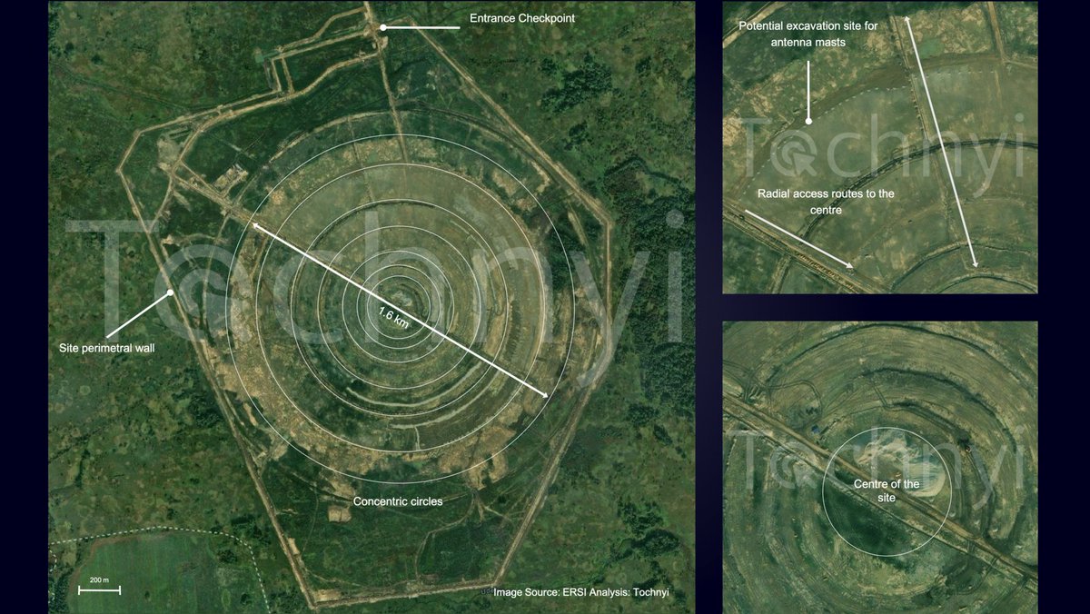
Thread✍️
Putin’s ears within Europe: Uncovering Kaliningrad’s Hidden Antenna Array
Deep within a dense forest in the secluded #KaliningradOblast, just 25 kilometres from the tranquil countryside along the eastern border of #Poland, a massive construction site is located at coordinates 54.562160, 21.827560.
tochnyi.info/2025/08/putins…
(High-resolution MAXAR satellite imagery of the site, accessed via the ArcGIS database, 17th September 2024.)
2
2/
This site, largely unknown outside of military analysis circles until recently, caught the attention of open-source researchers at @tochnyi, particularly due to its unusual geometry, impressive size, remote location and potential strategic significance, and we conducted an assessment using available satellite information..
In this article, we aim to provide a clearer understanding of what this installation might be, by analysing satellite imagery, conducting comparative studies and reviewing historical data related to signals intelligence infrastructure.
This site, largely unknown outside of military analysis circles until recently, caught the attention of open-source researchers at @tochnyi, particularly due to its unusual geometry, impressive size, remote location and potential strategic significance, and we conducted an assessment using available satellite information..
In this article, we aim to provide a clearer understanding of what this installation might be, by analysing satellite imagery, conducting comparative studies and reviewing historical data related to signals intelligence infrastructure.
3
2/
This site, largely unknown outside of military analysis circles until recently, caught the attention of open-source researchers at @tochnyi, particularly due to its unusual geometry, impressive size, remote location and potential strategic significance, and we conducted an assessment using available satellite information..
In this article, we aim to provide a clearer understanding of what this installation might be, by analysing satellite imagery, conducting comparative studies and reviewing historical data related to signals intelligence infrastructure.
This site, largely unknown outside of military analysis circles until recently, caught the attention of open-source researchers at @tochnyi, particularly due to its unusual geometry, impressive size, remote location and potential strategic significance, and we conducted an assessment using available satellite information..
In this article, we aim to provide a clearer understanding of what this installation might be, by analysing satellite imagery, conducting comparative studies and reviewing historical data related to signals intelligence infrastructure.
4
3/
The site was first flagged during routine satellite image reviews using open source platforms, more specifically the ARCGIS/ESRI database and later on Sentinel-2 data from the Copernicus database.
What can be noted immediately is the pattern of concentric circles, radially developing channels and a series of access routes to the centre.
The site, while the article is written, presents a complete perimetral wall and an access point with a checkpoint (54.5735, 21.8274).
While still under construction, this site, unlike typical infrastructure developments or radar installations, has no visible dispersed foundation works that anticipate the building of other solid structures within the perimeter, such as large antenna dishes or structures to protect radars, except for the centre, where the area has been levelled
The site was first flagged during routine satellite image reviews using open source platforms, more specifically the ARCGIS/ESRI database and later on Sentinel-2 data from the Copernicus database.
What can be noted immediately is the pattern of concentric circles, radially developing channels and a series of access routes to the centre.
The site, while the article is written, presents a complete perimetral wall and an access point with a checkpoint (54.5735, 21.8274).
While still under construction, this site, unlike typical infrastructure developments or radar installations, has no visible dispersed foundation works that anticipate the building of other solid structures within the perimeter, such as large antenna dishes or structures to protect radars, except for the centre, where the area has been levelled
5
4/
At least six concentric rings on the site can be identified, and upon closer examination, it appears that some soil movement has occurred at even spacing on the outer ring and along the entire perimeter.
These look like excavation points that could host poles, which can be used to support antennas.
The perfect circular symmetry, the equally spaced potential location for poles, the very few radially distributed roads and the central area, which looks like the only one which will host a building, suggested one specific facility:
- a military-grade antenna array designed for radio intelligence or communication, or better known as Circularly Disposed Antenna Array (CDAA).
At least six concentric rings on the site can be identified, and upon closer examination, it appears that some soil movement has occurred at even spacing on the outer ring and along the entire perimeter.
These look like excavation points that could host poles, which can be used to support antennas.
The perfect circular symmetry, the equally spaced potential location for poles, the very few radially distributed roads and the central area, which looks like the only one which will host a building, suggested one specific facility:
- a military-grade antenna array designed for radio intelligence or communication, or better known as Circularly Disposed Antenna Array (CDAA).
6
5/
The construction of this site began more than 2 years ago.
The first additional roadworks appeared on 18th March 2023. By April, construction at the northern part of the site had already started.
By May 2023, significant excavation and groundworks were visible, with two of the outer rings nearly defined.
However, a large part of the forest remained. The forest’s area seemed to be diminishing by July 2023, with most of it by then flattened and perimeter walls under construction.
Exactly one year later, the site appeared close to its final form, with all perimeter walls completed and a large number of secondary roads in place; - at this point, the development of radial roads could be observed.
Finally, in July 2025, several other areas designated for the location of buildings had been completed, and the site’s concentric circles were very clearly visible even from Sentinel-2 data.
(Construction progression of the site from March 2023 to July 2025)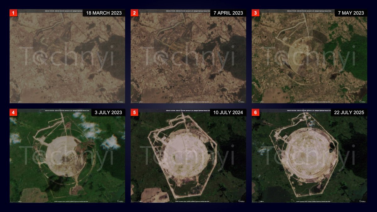
The construction of this site began more than 2 years ago.
The first additional roadworks appeared on 18th March 2023. By April, construction at the northern part of the site had already started.
By May 2023, significant excavation and groundworks were visible, with two of the outer rings nearly defined.
However, a large part of the forest remained. The forest’s area seemed to be diminishing by July 2023, with most of it by then flattened and perimeter walls under construction.
Exactly one year later, the site appeared close to its final form, with all perimeter walls completed and a large number of secondary roads in place; - at this point, the development of radial roads could be observed.
Finally, in July 2025, several other areas designated for the location of buildings had been completed, and the site’s concentric circles were very clearly visible even from Sentinel-2 data.
(Construction progression of the site from March 2023 to July 2025)
7
6/
A Circularly Disposed Antenna Array (CDAA) is a large circular field of vertical monopole antennas arranged in multiple concentric rings, designed to detect and determine the direction of incoming radio frequency signals.
These systems were widely deployed during the Cold War for signal direction finding, electronic surveillance, and submarine communications.
Examples of such installations are the FLR-9 CDAA at Elmendorf Air Base in Alaska, and that located at the communications base in Okinawa, Japan, or the newer FRD-10 in Bramstedtlund with a diameter of 410 metres.
CDAA works using a set of antennas arranged in a circular pattern, and the diameter of the circle has a direct impact on the frequency and, therefore, the wavelength of the waves used by the system.
Each CDAA can have multiple rings, one for each specific spectrum band, ranging from a few MHz to 28 MHz, with a detection range that can span up to 7400 km.
(AN/FLR-9 in Elmendorf, Alaska c. 1964)
A Circularly Disposed Antenna Array (CDAA) is a large circular field of vertical monopole antennas arranged in multiple concentric rings, designed to detect and determine the direction of incoming radio frequency signals.
These systems were widely deployed during the Cold War for signal direction finding, electronic surveillance, and submarine communications.
Examples of such installations are the FLR-9 CDAA at Elmendorf Air Base in Alaska, and that located at the communications base in Okinawa, Japan, or the newer FRD-10 in Bramstedtlund with a diameter of 410 metres.
CDAA works using a set of antennas arranged in a circular pattern, and the diameter of the circle has a direct impact on the frequency and, therefore, the wavelength of the waves used by the system.
Each CDAA can have multiple rings, one for each specific spectrum band, ranging from a few MHz to 28 MHz, with a detection range that can span up to 7400 km.
(AN/FLR-9 in Elmendorf, Alaska c. 1964)
8
7/
"CDAA arrays can intercept and locate radio signals from thousands of kilometres away."
They can detect submarine transmissions using Very Low Frequency (VLF) communication channels and support electronic warfare by mapping adversarial communication networks.
The system operates by comparing the phase and time differences of received signals across the antenna elements, computing their direction with extreme precision.
Using satellite imagery, the installation appears to span approximately few hundred to 1600 meters in diameter.
This places it well above the size range of known CDAAs, even those recently built in Cuba, allegedly in collaboration with China and covered by a recent investigation1 by the Centre for Strategic and International Studies (CSIS).
The construction site is currently in its initial phase, and due to the limited available data, it is challenging to draw a definitive conclusion about the site’s nature. However, several features suggest the possibility of a large-scale CDAA.
"CDAA arrays can intercept and locate radio signals from thousands of kilometres away."
They can detect submarine transmissions using Very Low Frequency (VLF) communication channels and support electronic warfare by mapping adversarial communication networks.
The system operates by comparing the phase and time differences of received signals across the antenna elements, computing their direction with extreme precision.
Using satellite imagery, the installation appears to span approximately few hundred to 1600 meters in diameter.
This places it well above the size range of known CDAAs, even those recently built in Cuba, allegedly in collaboration with China and covered by a recent investigation1 by the Centre for Strategic and International Studies (CSIS).
The construction site is currently in its initial phase, and due to the limited available data, it is challenging to draw a definitive conclusion about the site’s nature. However, several features suggest the possibility of a large-scale CDAA.
9
8/
Key features include:
• The site features a circular configuration with several evenly spaced excavation points, likely totalling 45 per quarter for a total of 180 over the entire circumference. These will accommodate vertical antennas.
• There is also a radial development of excavations from a central hub, suggesting the potential future presence of buried cables or signal feedlines. This is also evidenced by optical and SAR imagery.
• Additionally, a security perimeter has been established, complete with internal access roads and boundary fencing encircling the site.
(SAR imagery of the site from Sentinel-1 via the Copernicus database.)
Key features include:
• The site features a circular configuration with several evenly spaced excavation points, likely totalling 45 per quarter for a total of 180 over the entire circumference. These will accommodate vertical antennas.
• There is also a radial development of excavations from a central hub, suggesting the potential future presence of buried cables or signal feedlines. This is also evidenced by optical and SAR imagery.
• Additionally, a security perimeter has been established, complete with internal access roads and boundary fencing encircling the site.
(SAR imagery of the site from Sentinel-1 via the Copernicus database.)
10
9/
Kaliningrad is no ordinary russian oblast.
It is the westernmost exclave of the russian Federation, heavily militarised and home to the Baltic Fleet.
The region serves as a strategic forward base for advanced air defence systems such as the S-400, as well as nuclear-capable Iskander missile platforms.
Situated between #NATO member states #Poland and #Lithuania, Kaliningrad holds significant geopolitical importance.
(Location of the site in the Kaliningrad Oblast)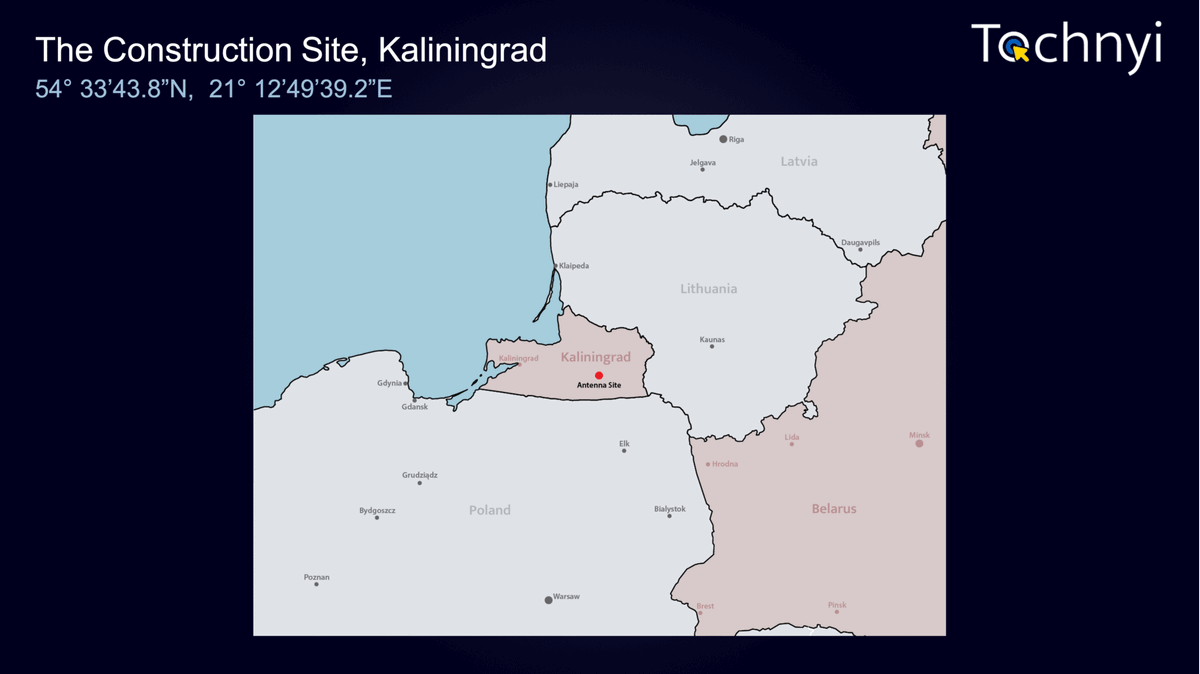
Kaliningrad is no ordinary russian oblast.
It is the westernmost exclave of the russian Federation, heavily militarised and home to the Baltic Fleet.
The region serves as a strategic forward base for advanced air defence systems such as the S-400, as well as nuclear-capable Iskander missile platforms.
Situated between #NATO member states #Poland and #Lithuania, Kaliningrad holds significant geopolitical importance.
(Location of the site in the Kaliningrad Oblast)
11
10/
The placement of a CDAA-like structure in this region is strategically logical.
Such an installation would enable russia to monitor NATO’s electronic communications across Eastern Europe and the Baltic region.
Very Low Frequency (VLF) or Low Frequency (LF) capabilities could facilitate communication with submerged submarines operating in the Baltic Sea or the North Atlantic.
Furthermore, such an installation would support passive intelligence gathering, aligning with russia’s broader electronic warfare doctrine, a core component of its modern hybrid warfare strategy.
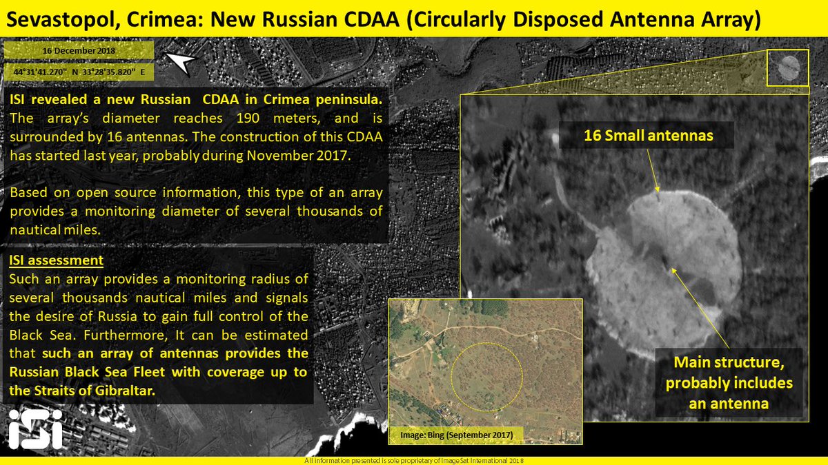
To confirm the scale of the Kaliningrad array, we compared its design with several well-documented Circularly Disposed Antenna Arrays (CDAAs) around the world, such as the one operated and still active in Bramstedtlud (48.45121, 10.86275), which is one of the largest built at 410 metres in diameter, hosting several SIGINT facilities and personnel.
In this analysis, we also included those built recently by russia, like the one in the occupied Crimean peninsula in 2018 and uncovered by ImageSat int2.
(CDAA installation in occupied Crimea near Sevastopol, identified by ISI.)
The placement of a CDAA-like structure in this region is strategically logical.
Such an installation would enable russia to monitor NATO’s electronic communications across Eastern Europe and the Baltic region.
Very Low Frequency (VLF) or Low Frequency (LF) capabilities could facilitate communication with submerged submarines operating in the Baltic Sea or the North Atlantic.
Furthermore, such an installation would support passive intelligence gathering, aligning with russia’s broader electronic warfare doctrine, a core component of its modern hybrid warfare strategy.
To confirm the scale of the Kaliningrad array, we compared its design with several well-documented Circularly Disposed Antenna Arrays (CDAAs) around the world, such as the one operated and still active in Bramstedtlud (48.45121, 10.86275), which is one of the largest built at 410 metres in diameter, hosting several SIGINT facilities and personnel.
In this analysis, we also included those built recently by russia, like the one in the occupied Crimean peninsula in 2018 and uncovered by ImageSat int2.
(CDAA installation in occupied Crimea near Sevastopol, identified by ISI.)
12
11/
The Sevastopol CDAA relies on a similar configuration, potentially based on the Krug design, and features the characteristic spoke-and-ring structure, but with its apparent dimensions being significantly larger.
The layout seen in Kaliningrad is similar to all the CDAAs;
- it is located in a remote area to minimise interference and maximise signal reception.
The Krug CDAA system was the Soviet Union’s circularly disposed antenna arrays (CDAAs) based on German Wullenweber technology3.
The Soviets used the generic term “Krug” (meaning “circle”) for all such systems, while NATO specifically applied this designation only to the largest variant, massive arrays 200-300 meters in diameter with 40 antenna towers surrounding a 105-meter vertical screen resembling a circular fence.
A total of 31 Krug systems were built during the Cold War4.
(Map from CIA report on KURG installation in USSR during the Cold War)
The Sevastopol CDAA relies on a similar configuration, potentially based on the Krug design, and features the characteristic spoke-and-ring structure, but with its apparent dimensions being significantly larger.
The layout seen in Kaliningrad is similar to all the CDAAs;
- it is located in a remote area to minimise interference and maximise signal reception.
The Krug CDAA system was the Soviet Union’s circularly disposed antenna arrays (CDAAs) based on German Wullenweber technology3.
The Soviets used the generic term “Krug” (meaning “circle”) for all such systems, while NATO specifically applied this designation only to the largest variant, massive arrays 200-300 meters in diameter with 40 antenna towers surrounding a 105-meter vertical screen resembling a circular fence.
A total of 31 Krug systems were built during the Cold War4.
(Map from CIA report on KURG installation in USSR during the Cold War)
13
12/
These arrays were part of a family of Soviet CDAAs that included several other types.
The Fix-24 was a smaller dual-band system with concentric rings of antennas spanning 150-200 meters, while the compact “Thick Eight” used just eight caged antennas similar to those in Krug arrays, deployed across the USSR, Warsaw Pact nations, and China.
Some specialised CDAAs were also linked to the Soviet Duga over-the-horizon (OTH) radar stations, suggesting a role in radar signal processing or electronic intelligence.
The original Wullenweber design, including sites like the one in Augusta, Germany, served as the foundation for these systems, characterised by their circular antenna screens and radial element arrangements5.
While still under construction, this new installation in Kaliningrad is likely a core node in russia’s strategic signals intelligence and communications architecture.
It represents a bridge between Cold War technology and modern military doctrine, one that values deniability, surveillance, and information dominance.
In an age where most defence infrastructure is hidden, digitised, or dispersed, this visible site of RF intelligence will operate just 25 km from NATO’s doorstep.
These arrays were part of a family of Soviet CDAAs that included several other types.
The Fix-24 was a smaller dual-band system with concentric rings of antennas spanning 150-200 meters, while the compact “Thick Eight” used just eight caged antennas similar to those in Krug arrays, deployed across the USSR, Warsaw Pact nations, and China.
Some specialised CDAAs were also linked to the Soviet Duga over-the-horizon (OTH) radar stations, suggesting a role in radar signal processing or electronic intelligence.
The original Wullenweber design, including sites like the one in Augusta, Germany, served as the foundation for these systems, characterised by their circular antenna screens and radial element arrangements5.
While still under construction, this new installation in Kaliningrad is likely a core node in russia’s strategic signals intelligence and communications architecture.
It represents a bridge between Cold War technology and modern military doctrine, one that values deniability, surveillance, and information dominance.
In an age where most defence infrastructure is hidden, digitised, or dispersed, this visible site of RF intelligence will operate just 25 km from NATO’s doorstep.
14
@tochnyi 13/13
Sources:
1. features.csis.org/hiddenreach/sn… ↩︎
2.
3. googleearthcommunity.proboards.com/thread/246/sov…
4. cia.gov/readingroom/do…
5. globalsecurity.org/intell/world/r…

Sources:
1. features.csis.org/hiddenreach/sn… ↩︎
2.
3. googleearthcommunity.proboards.com/thread/246/sov…
4. cia.gov/readingroom/do…
5. globalsecurity.org/intell/world/r…
ImageSat Intl.@ImageSatIntl
ISI reveales: new Russian KRUG CDAA in #Sevastopol, #Crimea peninsula, probably provides the #Russian Black Sea Fleet with coverage from the Black Sea up to the Straits of #Gibraltar. The full #intelligence #report is in #imagesat website: imagesatintl.com/new-russian-cd…