Canvas & Ratio
Choose your destination platform format
Layout Template
Choose a content structure for your slides
Preset Themes
Typography & Sizing
Brand Kit Customization
AGENCYConfigure brand assets for headers & footers
Outro Slide CTA
Customize your closing call-to-action slide
Background Pattern
Build Your Carousel
Drag and drop any post card below onto a slide, or use the quick buttons to insert content/images instantly!

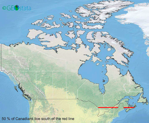
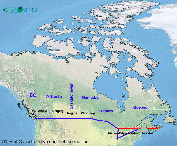
You've probably seen this viral map of Canada: 50% of the country's population lives under the red line Here's a quick explainer🧵
Canada is the 2nd largest country in the world by landmass (as a Canadian, this fun fact was oft-repeated in elementary school): 1. Russia (17 million Km²) 2. Canada (10 million Km²) 3. USA (9.8 million Km²) 4. China (9.6 million Km²) 5. Brazil (8.5 million Km²)
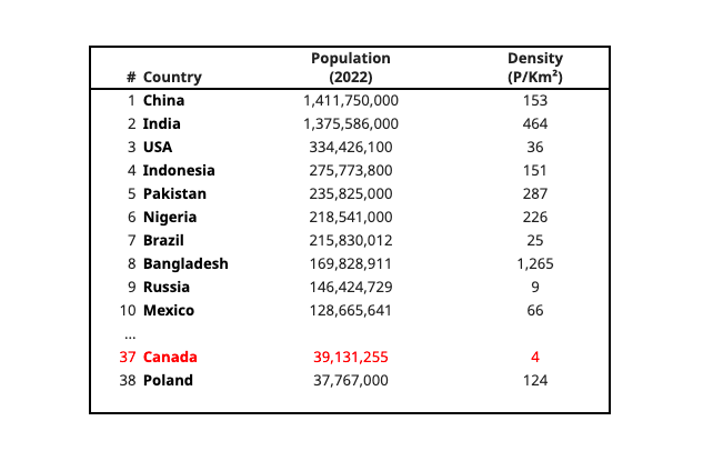
But Canada is only the 37th most-populous country in the world. And it has a very low population density (at 39m people, Canada has about the same population as California).
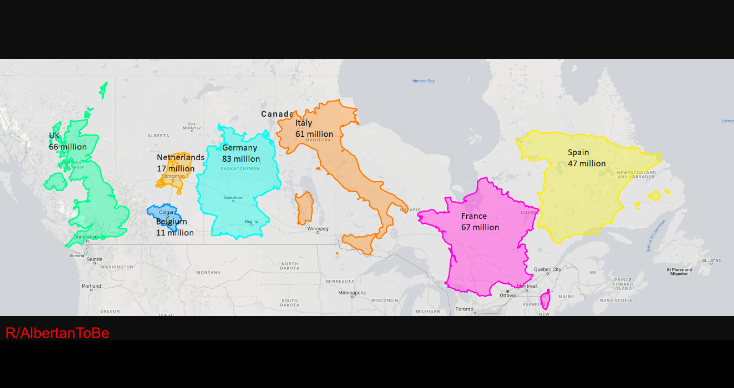
Here is a map with the land masses for the UK, Netherlands, Belgium, Italy, France and Spain all fitting inside Canada. Those European countries have a combined 352 million people, nearly 10x Canada's population.
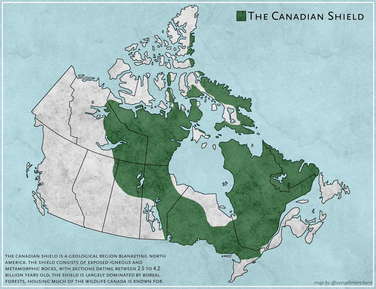
Why is Canada so sparsely populated? Because most of the country's landmass is largely uninhabitable: 8 million Km² is made up of The Canadian Shield, a large area of exposed rock with very little top soil. And that little soil is usually frozen from long winters.
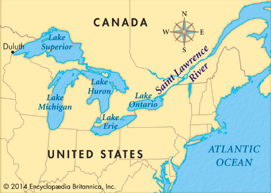
Now, let's go back to the 1500s. When European explorers — in this case France — crossed the Atlantic, they entered what is now the Canadian land mass through the St. Lawrence Seaway, one of world's largest and deepest estuaries.
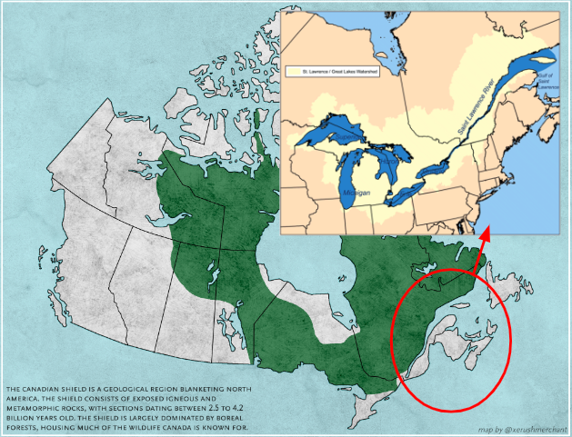
In the following centuries, English explorers also went through the St. Lawrence. The colonial powers established settlements in Quebec and then Ontario. Crucially, land in the region — particularly near The Great Lakes — is very fertile (especially vs. The Canadian Shield).
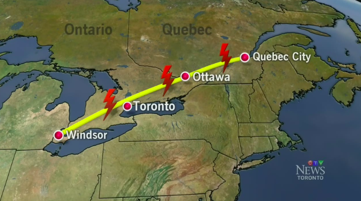
While Canada expanded West in late-1800s and early-1900s (Saskatchewan, Manitoba, Alberta, BC), population centers around Toronto and Montreal remain the largest. Also, metropolitan areas around Toronto, Montreal and Ottawa and Quebec are 1/3rd of the country's population.
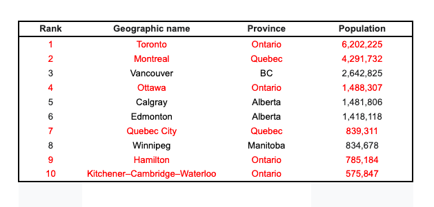
Now, add up *all* the population centres from Quebec City, Quebec to Windsor, Ontario (it's known as the Quebec City-Windsor Corridor and is 1,150km long). This region tracks to the European St.Lawrence sailing path and contains 50% of Canada's current population.
So, ~50% of Canada's population is concentrated under the red line (Quebec-City - Windsor Corridor). And the major population centres in the West are near the US border. One last fun fact: 85%+ of Canada's entire population lives within 160km (or 100 miles) of the US border.
If you enjoyed that, follow me — a very Canadian dude — for other interesting threads. And subscribe to my business newsletter including previous issues on: • Why is Linkedin so cringe? • The worst tech predictions ever • Psychology of Apple packaging <a target="_blank" href="https://trungphan.substack.com/" color="blue">trungphan.substack.com</a>
PS. If you’re like me and consume a ton of content, check out my AI-powered research app <a target="_blank" href="http://Bearly.AI" color="blue">Bearly.AI</a> that boosts: • Reading (instant summaries) • Writing (rewording, grammar correction, auto-generated text) • My dopamine levels on every sign-up Try it free:
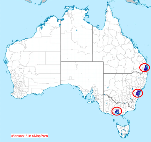
Australia has a similarly interesting map: 50% of the country's population lives in these three major centres (Melbourne, Sydney, Brisbane). In fact, Australia's population (3.4 people per Km²) is among the world's lowest and less dense than Canada (4 people per Km²).
<a target="_blank" href="https://twitter.com/markmcan/status/1631358828443758593" color="blue">x.com/markmcan/statu…</a>
Credit to @DaniMermelstein for completely wrecking me lol
Creddit to Ross for wrecking me for fixating on the Quebec City-Windsor Corridor and ignoring Nova Scotia <a target="_blank" href="https://twitter.com/TheCoolestCool/status/1631367309280305154?s=20" color="blue">x.com/TheCoolestCool…</a>