THREAD🧵 Significance of Siliguri Corridor Few geographical features...

Netram Defence Review@NetramDefence
9 views
Jul 24, 2026
~4 min read
Advertisement
1
THREAD🧵
Significance of Siliguri Corridor
Few geographical features carry as much strategic importance as the Siliguri Corridor, popularly known as the “Chicken’s Neck.” This narrow strip of land in northern West Bengal is the only continuous land bridge connecting mainland India to its eight northeastern states. Every military planner, policymaker and strategist recognizes it as one of India’s most critical national security vulnerabilities.
@adgpi
@AN_Command
@NorthernComd_IA
@IAF_MCC
@westerncomd_I
@indiannavy
@easterncomd
@official_dg
@IaSouthern
@HQ_IDS_India
@IN_HQENC
@SpokespersonMoD
@IN_WNC
@DefenceMinIndia
@rajnathsingh
@rashtrapatibhvn
1/
Significance of Siliguri Corridor
Few geographical features carry as much strategic importance as the Siliguri Corridor, popularly known as the “Chicken’s Neck.” This narrow strip of land in northern West Bengal is the only continuous land bridge connecting mainland India to its eight northeastern states. Every military planner, policymaker and strategist recognizes it as one of India’s most critical national security vulnerabilities.
@adgpi
@AN_Command
@NorthernComd_IA
@IAF_MCC
@westerncomd_I
@indiannavy
@easterncomd
@official_dg
@IaSouthern
@HQ_IDS_India
@IN_HQENC
@SpokespersonMoD
@IN_WNC
@DefenceMinIndia
@rajnathsingh
@rashtrapatibhvn
1/
2
2/
The Geography of a Chokepoint
The corridor stretches for roughly 60 km while narrowing to only about 20–22 km at its slimmest point. Such an exceptionally narrow passage creates a classic geopolitical chokepoint, where even localized disruptions could have disproportionately large military, economic and humanitarian consequences.
The Geography of a Chokepoint
The corridor stretches for roughly 60 km while narrowing to only about 20–22 km at its slimmest point. Such an exceptionally narrow passage creates a classic geopolitical chokepoint, where even localized disruptions could have disproportionately large military, economic and humanitarian consequences.
3
3/
Surrounded by International Borders
The corridor is enclosed by multiple international frontiers:
• Nepal to the west
• Bhutan to the north and northeast
• Bangladesh to the south
Most importantly, it lies roughly 130 km south of China’s Chumbi Valley, a narrow wedge of Tibetan territory extending between Bhutan and Sikkim. This geography has shaped military planning in the eastern Himalayas for decades.
Surrounded by International Borders
The corridor is enclosed by multiple international frontiers:
• Nepal to the west
• Bhutan to the north and northeast
• Bangladesh to the south
Most importantly, it lies roughly 130 km south of China’s Chumbi Valley, a narrow wedge of Tibetan territory extending between Bhutan and Sikkim. This geography has shaped military planning in the eastern Himalayas for decades.
4
4/
Why the Corridor Exists
The Siliguri Corridor assumed its present importance after the Partition of 1947. Prior to Partition, India’s northeastern provinces were connected through extensive transport networks passing across what became East Pakistan (now Bangladesh). The creation of new international borders abruptly severed these routes, leaving the Siliguri Corridor as India’s principal land connection to the Northeast.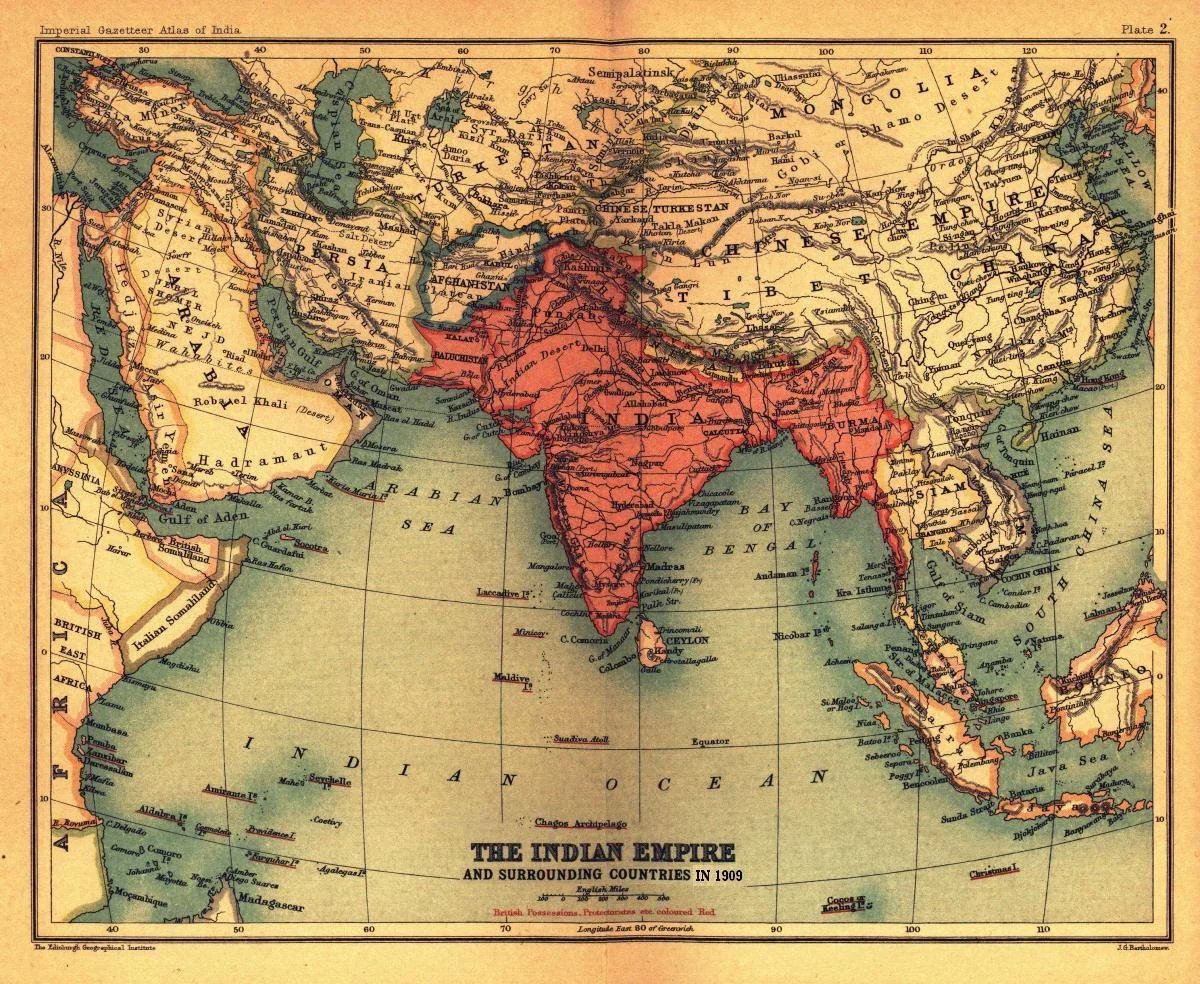
Why the Corridor Exists
The Siliguri Corridor assumed its present importance after the Partition of 1947. Prior to Partition, India’s northeastern provinces were connected through extensive transport networks passing across what became East Pakistan (now Bangladesh). The creation of new international borders abruptly severed these routes, leaving the Siliguri Corridor as India’s principal land connection to the Northeast.
5
5/
More Than Just a Road
Today, the overwhelming majority of mainland India’s connectivity with the Northeast still depends on this corridor. It carries:
• National Highways
• Major railway corridors
• Petroleum and LPG pipelines
• High-voltage power transmission lines
• Optical fibre communication cables
• Commercial freight and passenger traffic
This makes the corridor indispensable not only for defence but also for governance, commerce and public services.
More Than Just a Road
Today, the overwhelming majority of mainland India’s connectivity with the Northeast still depends on this corridor. It carries:
• National Highways
• Major railway corridors
• Petroleum and LPG pipelines
• High-voltage power transmission lines
• Optical fibre communication cables
• Commercial freight and passenger traffic
This makes the corridor indispensable not only for defence but also for governance, commerce and public services.
6
6/
The Economic Lifeline
Over 45 million people across the Northeastern states depend directly or indirectly on uninterrupted movement through the corridor. Daily supplies including food grains, medicines, fuel, construction materials, industrial goods and consumer products move through this gateway. Any prolonged disruption would have cascading economic and humanitarian consequences across the region.
The Economic Lifeline
Over 45 million people across the Northeastern states depend directly or indirectly on uninterrupted movement through the corridor. Daily supplies including food grains, medicines, fuel, construction materials, industrial goods and consumer products move through this gateway. Any prolonged disruption would have cascading economic and humanitarian consequences across the region.
7
7/
The Military Lifeline
For the Indian Armed Forces, the corridor is a strategic necessity. The vast majority of heavy ground logistics, armored vehicles, artillery, engineering equipment, ammunition and troop reinforcements moving toward Sikkim and much of the Northeast transit through this narrow passage. Although the Indian Air Force provides strategic airlift capabilities, sustained military operations require robust ground logistics flowing through the corridor.
The Military Lifeline
For the Indian Armed Forces, the corridor is a strategic necessity. The vast majority of heavy ground logistics, armored vehicles, artillery, engineering equipment, ammunition and troop reinforcements moving toward Sikkim and much of the Northeast transit through this narrow passage. Although the Indian Air Force provides strategic airlift capabilities, sustained military operations require robust ground logistics flowing through the corridor.
8
8/
Why Doklam Mattered
The importance of the corridor became evident during the 2017 Doklam standoff. Chinese road construction near the India–Bhutan–China tri-junction raised Indian concerns that any significant alteration in the military balance around the Chumbi Valley could increase strategic pressure on the Siliguri Corridor. The standoff demonstrated why even seemingly remote Himalayan terrain can have direct implications for India’s national security.
Why Doklam Mattered
The importance of the corridor became evident during the 2017 Doklam standoff. Chinese road construction near the India–Bhutan–China tri-junction raised Indian concerns that any significant alteration in the military balance around the Chumbi Valley could increase strategic pressure on the Siliguri Corridor. The standoff demonstrated why even seemingly remote Himalayan terrain can have direct implications for India’s national security.
9
9/
India’s Layered Defence
Recognizing its vulnerability, India maintains one of its most heavily protected strategic regions here.
The defence architecture includes:
• XXXIII Corps headquartered at Sukna
• Trishakti Corps responsible for Sikkim
• Sashastra Seema Bal (SSB) guarding international borders
• Indian Air Force assets
• Intelligence agencies
• Integrated surveillance and rapid-response capabilities
Together, they form a multi-layered deterrence against both conventional and hybrid threats.
India’s Layered Defence
Recognizing its vulnerability, India maintains one of its most heavily protected strategic regions here.
The defence architecture includes:
• XXXIII Corps headquartered at Sukna
• Trishakti Corps responsible for Sikkim
• Sashastra Seema Bal (SSB) guarding international borders
• Indian Air Force assets
• Intelligence agencies
• Integrated surveillance and rapid-response capabilities
Together, they form a multi-layered deterrence against both conventional and hybrid threats.
10
10/
Building Strategic Resilience India has invested heavily in strengthening infrastructure around the corridor.
Projects include:
• Highway expansion
• Railway doubling and electrification
• Bridge modernization
• Logistics hubs
• Additional airfields
• Improved communications networks
These developments improve both civilian connectivity and military mobilization during emergencies.
Building Strategic Resilience India has invested heavily in strengthening infrastructure around the corridor.
Projects include:
• Highway expansion
• Railway doubling and electrification
• Bridge modernization
• Logistics hubs
• Additional airfields
• Improved communications networks
These developments improve both civilian connectivity and military mobilization during emergencies.
11
11/
Reducing Dependence on One Route
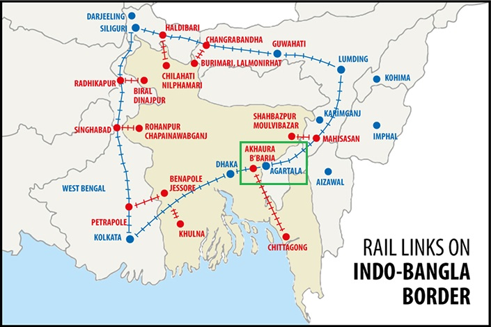
Recognizing the risks of relying on a single land corridor, India has pursued alternative connectivity through Bangladesh.
Today, access to the Northeast is increasingly supported by:
• Chattogram Port
• Mongla Port
• Inland waterways under the Protocol on Inland Water Transit and Trade (PIWTT)
• Cross-border rail connectivity
• Integrated road transport agreements
These initiatives provide valuable strategic redundancy during both peacetime and crises.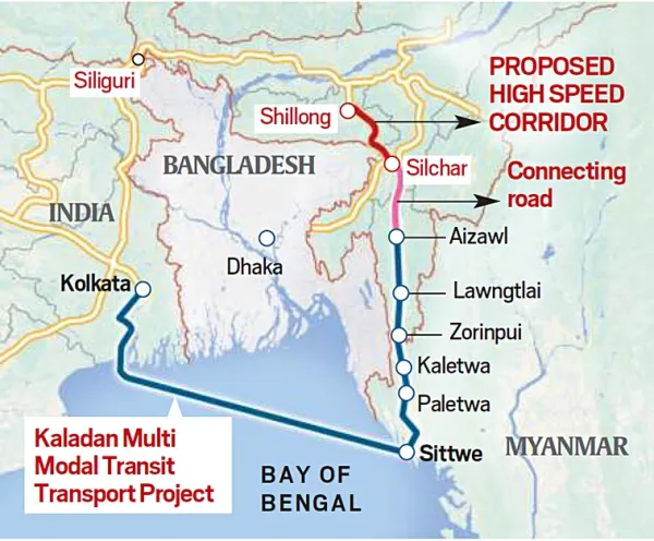

Reducing Dependence on One Route
Recognizing the risks of relying on a single land corridor, India has pursued alternative connectivity through Bangladesh.
Today, access to the Northeast is increasingly supported by:
• Chattogram Port
• Mongla Port
• Inland waterways under the Protocol on Inland Water Transit and Trade (PIWTT)
• Cross-border rail connectivity
• Integrated road transport agreements
These initiatives provide valuable strategic redundancy during both peacetime and crises.
12
12/
The BBIN Vision
The Bangladesh–Bhutan–India–Nepal (BBIN) initiative seeks to transform eastern South Asia into an integrated economic region. Greater regional connectivity through BBIN reduces transport costs, improves trade efficiency and enhances India’s strategic flexibility by diversifying access routes to the Northeast.
The BBIN Vision
The Bangladesh–Bhutan–India–Nepal (BBIN) initiative seeks to transform eastern South Asia into an integrated economic region. Greater regional connectivity through BBIN reduces transport costs, improves trade efficiency and enhances India’s strategic flexibility by diversifying access routes to the Northeast.
13
13/
Beyond National Security
The Siliguri Corridor is not merely a military concern. It serves as a gateway for trade with Nepal, Bhutan and Bangladesh, supports tourism, facilitates energy cooperation and underpins regional economic integration across eastern South Asia. Its stability directly influences both India’s domestic economy and its broader neighbourhood diplomacy.
Beyond National Security
The Siliguri Corridor is not merely a military concern. It serves as a gateway for trade with Nepal, Bhutan and Bangladesh, supports tourism, facilitates energy cooperation and underpins regional economic integration across eastern South Asia. Its stability directly influences both India’s domestic economy and its broader neighbourhood diplomacy.
14
14/
A Lesson in Geopolitics
The Siliguri Corridor illustrates one of geopolitics’ oldest realities: geography shapes strategy. A strip of land barely 20 km wide influences military planning, infrastructure development, diplomacy, disaster management, economic resilience and national security for an entire region
A Lesson in Geopolitics
The Siliguri Corridor illustrates one of geopolitics’ oldest realities: geography shapes strategy. A strip of land barely 20 km wide influences military planning, infrastructure development, diplomacy, disaster management, economic resilience and national security for an entire region
15
15/
Conclusion
The Siliguri Corridor is far more than a narrow passage on the map. It is India’s strategic lifeline to the Northeast, a corridor where geography, history, diplomacy and military preparedness converge. Protecting this vital artery through robust defence, resilient infrastructure and diversified connectivity remains one of India’s foremost strategic imperatives in the 21st century.
Conclusion
The Siliguri Corridor is far more than a narrow passage on the map. It is India’s strategic lifeline to the Northeast, a corridor where geography, history, diplomacy and military preparedness converge. Protecting this vital artery through robust defence, resilient infrastructure and diversified connectivity remains one of India’s foremost strategic imperatives in the 21st century.