@singhshwetabh71: Alright lets get started with ...
@singhshwetabh71
7 views
Mar 17, 2026
Advertisement
1
Alright lets get started with NaviC then.
You are by now already aware on how basic ranging works and position is solved for from a GNSS constellation. We will look at a basic structure of the constellation, how the signal is generated, rcv'd and solved for.
You are by now already aware on how basic ranging works and position is solved for from a GNSS constellation. We will look at a basic structure of the constellation, how the signal is generated, rcv'd and solved for.

2
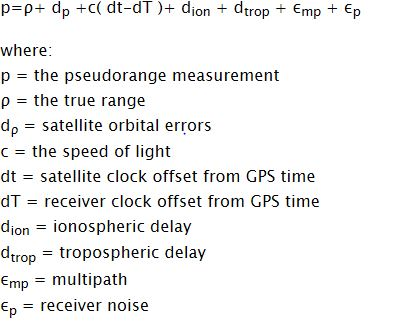
First lets look at the basic maths behind the positioning and our general sources of error. The basic term you need to know is called pseudorange. we will come to it later

3
Now lets start with the satellites of NaviC. GPS orbits 31 MEO satellites at ~20,200 km in 6 orbital
planes inclined at 55°. Any ground observer sees satellites sweeping across the entire sky dome over a ~12hr orbital period. Navic takes a diff approach
planes inclined at 55°. Any ground observer sees satellites sweeping across the entire sky dome over a ~12hr orbital period. Navic takes a diff approach
4
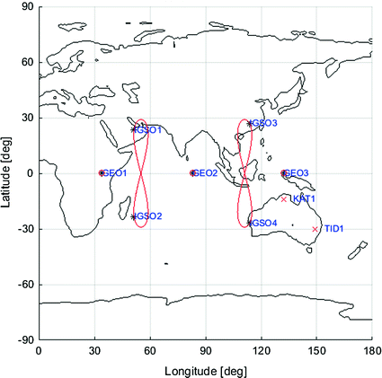
Navic has 3 GEOs that sit at fixed longitude slots and 4 IGSOs orbit in two planes crossing the equator at 55°E and 111.75°E. Because their orbital period exactly matches Earth's rotation, IGSOs trace a fig8 ground track straddling the equator, over India for the
majority of day
majority of day
5
This arrangement means from anywhere in India, GEO satellites appear as immovable high elv points the full constellation covers the primary service area with 100% availability of ≥4 satellites with just 7 sv. All satellites reside at the same ~35,786 km altitude.
6
One minor tradeoff is there are no low-elevation satellites to triangulate vertical position. This yields
NavIC-standalone PDOP values of 3.3 to 6.2 versus GPS's ~1.5-2.5.
All you need to know about PDOP is, its a measure of quality and depends on satellite geometry.
NavIC-standalone PDOP values of 3.3 to 6.2 versus GPS's ~1.5-2.5.
All you need to know about PDOP is, its a measure of quality and depends on satellite geometry.
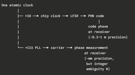
7
Onboard each satellite is a clock, and it is this clock that is the heart of the entire positioning. This clock's measurements will cascade down to earth. This clock simultaneously creates both the chip sequence (code) and the carrier wave on which chips are encoded
8
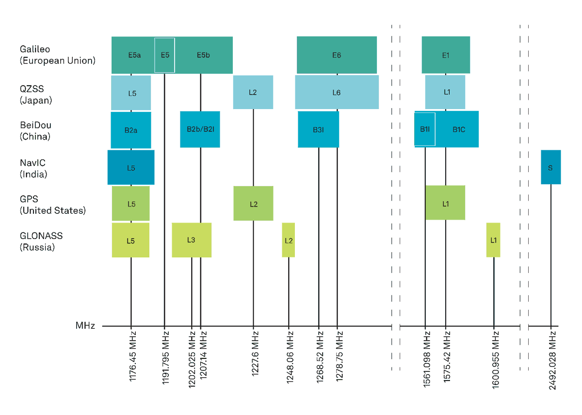
Here comes one of the pri differences in GPS and Navic. Navic instead of using a single frequency uses two bands to encode messages in L5 and S from each satellite. Technically even GPS now uses multiple bands L1 L2 L5
-L5 is shared with GPS L5 and GAL E5a
-S unique to NaviC
-L5 is shared with GPS L5 and GAL E5a
-S unique to NaviC

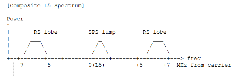
9
There are two services onboard NaviC, the SPS or Standard Positioning Service for civilian app and RS or Restricted Service for mil app. RS shifts spectral energy to ±5.115 MHz lobes around the carrier separating them spectrally and allow
simul broadcast w/o mutual degradation
simul broadcast w/o mutual degradation
10
The NVS-01/02 satellites add L1 (1575.42 MHz) using SBOC modulation (a composite
BOC variant), interoperable with GPS L1C and Galileo E1-OS.
Both NavIC freq travel ~35,786 km to the ground through the same atmosphere. 3layers matter: vacuum path, ionosphere, troposphere.
BOC variant), interoperable with GPS L1C and Galileo E1-OS.
Both NavIC freq travel ~35,786 km to the ground through the same atmosphere. 3layers matter: vacuum path, ionosphere, troposphere.
11
Look back at the pseudorange equation, you can see them as the sources of error. Now, you can either use a model to estimate ionospheric and tropo electron activity or you can use a smart trick that NaviC does from its dual freq.
12
S-band sees ~4.5× less ionospheric delay than L5. Over India's equatorial ionosphere, daytime TEC can spike to 60-100 TECU during solar max,
causing >1.7 m of L5 delay. India is also near equatorial ionospheric anomaly, where post-sunset plasma bubbles cause rapid signal fading.
causing >1.7 m of L5 delay. India is also near equatorial ionospheric anomaly, where post-sunset plasma bubbles cause rapid signal fading.
13
The freq separation of NavIC ( ≈ 2.12) is much larger than GPS L1/L2 (≈ 1.28), making NavIC's iono-free combination ~1.79× less noise-amplifying than GPS L1/L2's (~2.98× amplification). And S-band's lower scintillation directly reduces cycle slips in PLL tracking
14
If you measure pseudoranges on two frequencies f₁ and f₂, the iono delay scales differently on each, and you can use them to calculate that a IonoFree pseudorange which is independent of TEC. No model needed
15
Free-space path loss scales as f², so S-band (2492 MHz) arrives at the receiver~6.5 dB weaker than L5 (1176 MHz) for equal transmit power. So the satellites transmits S-band at ~3.5 dB higher power
(~29.5 dBW vs ~26 dBW for L5), to compensate
(~29.5 dBW vs ~26 dBW for L5), to compensate
16
Both the bands have their own characteristics and the NavIC receivers are made to receive both together and solve, but due to diff atmospheric events (and other things) you can have band specific degradation as well
17
Both bands tracked -> iono-free combination, ~3-5 m accuracy
L5 only -> ~10-20 m
S-band only -> model fallback, raw S delay 4.5x smaller than L5
Neither -> satellite excluded from PVT for that epoch
L5 only -> ~10-20 m
S-band only -> model fallback, raw S delay 4.5x smaller than L5
Neither -> satellite excluded from PVT for that epoch
18
There is a integrity flag in the navigation message signals whether dual-band correction is healthy for a given satellite, so the receiver always knows which
operating mode it is in.
operating mode it is in.
19
So know we know, how the satellites transmit it, how about the receivers which receive it. Firstly the antennas themselves have to be made to be able to detect not only Navic's spread out frequencies but other constellations (usually GPS) as well
20
Btw you need to be aware of level of signal strength once these signals reach earth (and that will give you an idea about jamming them as well)

21
So navic receivers must run two independent RF chains from two antenna port Each chain has its own LNA, BPF, downconverter, AGC, and ADC. It also means it can handle limited jamming if you jam a single band.
22
So now the receiver has gotten those messages (not going over search, tracking and locking part) With N ≥ 4 satellites and their corrected pseudoranges, the reciever can solve for its own ECEF position [x, y, z] (or the antenna's) and receiver clock bias

23
And that is how navic works, a single clock creates messages and waves that travel >30000km to the surface of the earth and tell you where you are (and when you are) in real time.
Let me know if i made any errors, happy to correct
Let me know if i made any errors, happy to correct
24
25
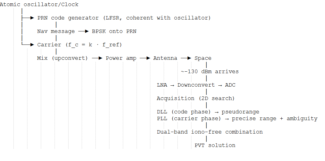
So in short, below.
And now you know why the 4 failing clock is such a big problem for the NavIC as a whole
And now you know why the 4 failing clock is such a big problem for the NavIC as a whole